Manage spatial data in a simple, fast and inexpensive way
Allows you to easily work with GIS related data and aerial imagery.

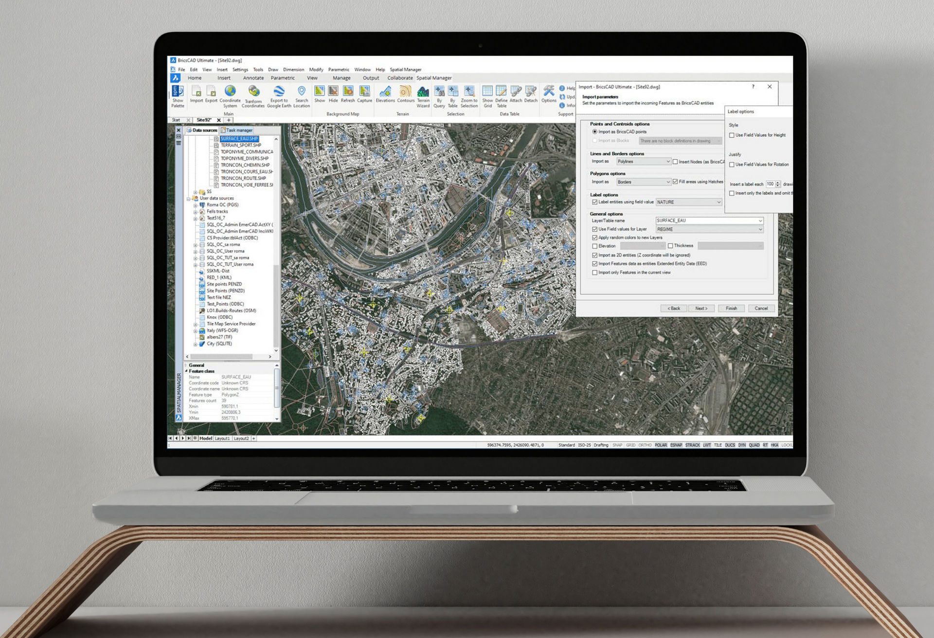
Spatial Manager™ for BricsCAD (and AutoCAD) is a powerful plug-in that allows you to import and export geospatial data between BricsCAD drawings and geospatial files, data servers or data stores, display background maps and manage alphanumeric data and data tables. Coupled with an intuitive interface you'll find that Spatial Manager will greatly enhance your productivity.
Key Benefits
Features
Spatial manager allows you to:-
- Import into BricsCAD from Google Earth (KML or KMZ), OpenStreetMap (OSM or PBF), Shapefiles (SHP), GPS, Points (many formats), Excel, Access, ESRI ArcInfo®, MapInfo, GML (GML or GZ), PostGIS, SQL Server, SQLite, and many more geospatial sources.
- Export from BricsCAD to Google Earth (KML or KMZ), Shapefiles (SHP), Points (many formats), MapInfo, PostGIS, SQL Server, SQLite, and many more geospatial targets.
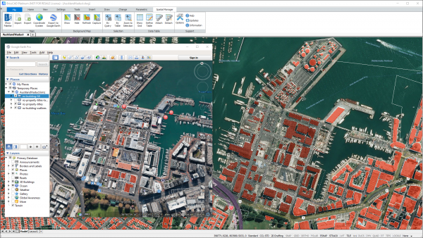
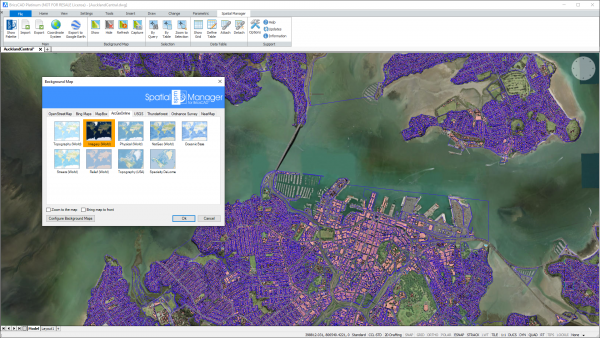
- Attach Backgrounds Maps, powerful and easy to use.
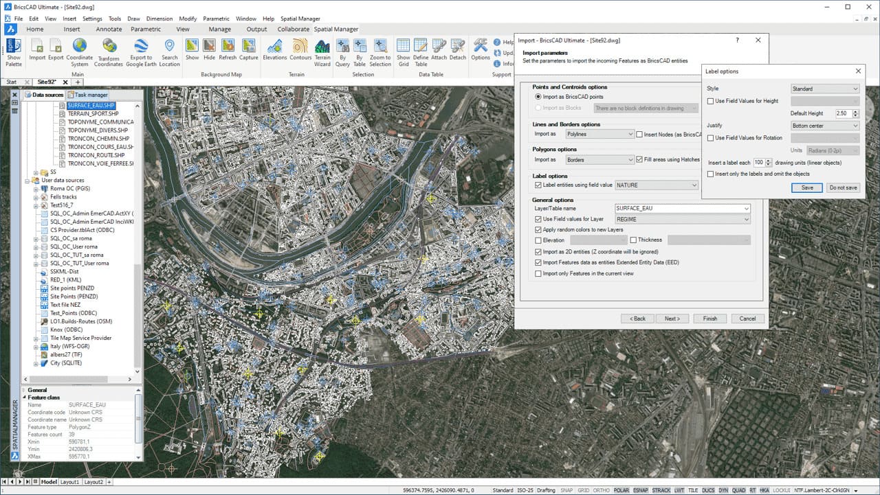
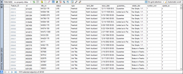
- Alphanumeric data tables as BricsCAD Extended Entity Data (EED). Manage data tables and fields. Data viewer and editor included.
- Save Tasks to replay the import processes so many times as desired.
- A Simple, which is intuitive to use and allows you to be more productive
- Perpetual licenses. Pay once, no periodic fees.
Introductory Video
Videos
Export from BricsCAD
Attached background maps
Alphanumeric data tables
Manage data tables and fields
Save tasks to replay
Spatial Manager for BricsCAD
Import from Google Earth (KML or KMZ), OpenStreetMap (OSM or PBF), Shapefiles (SHP), GPS, Points (many formats), Excel, Access, ESRI ArcInfo®, MapInfo, GML (GML or GZ), PostGIS, SQL Server, SQLite, and many more geospatial sources.
Spatial Manager - Transform coordinate systems
The functionality of transforming the coordinate system (CRS) of a drawing in ONE STEP is one of the tools most requested by the application users. This operation, which in some cases presents a high geometric complexity, is totally transparent and provides a transformed copy of the drawing without losing any of its properties
Request A Trial
Screenshots
Request A Demo
If you'd like a demo, then please complete the form below and we'll be in touch with you to arrange a suitable time.
BricsCAD Licensing and Pricing
It's your choice.
Whether you prefer Perpetual or Subscription licenses, need different license levels, or want to choose between single‑user and network deployments, BricsCAD gives you the freedom to select the option that best fits your budget and your workflow requirements. The choice is yours!
In addition to single stand‑alone licenses, BricsCAD also offers flexible Network License options. A Network License allows you to share BricsCAD seats among multiple users on your network, making it ideal for organisations with multiple casual or part‑time users, or for those wanting to centralise BricsCAD license management.
Management is straightforward, and you can make BricsCAD available to as many users as required. Network users can also “check out” a license for offline use, enabling continued work away from the office. While the upfront cost of a network license is higher than a single‑user seat, the ongoing cost per user can be significantly lower when shared across several team members.
Pricing (exc. GST)
Perpetual Licenses: Perpetual licenses are just that. Pay once and continue to use for as long as you have a system to support it. Maintenance is mandatory for all new license purchases for the first year. Annual maintenance is optional from the second year on and is the most cost-effective way to keep your BricsCAD up to date.
Subscription Licenses: Prefer a subscription based option? That’s available too.
Single licenses give you ultimate flexibility in how you utilise BricsCAD and is well suited to individuals and smaller organisations. Feel free to contact us to discuss your options.
Network licenses allows you to share a seat of BricsCAD across multiple users on your company network and can be very cost effective. Management is simple, and you can make BricsCAD available to as many users as you like. There are some additional requirements needed to use a Network license, so we recommend that you talk to us to confirm that it will work for you.
All prices are GST exclusive.
* Price is inclusive of maintenance & support. This is mandatory for the first year for perpetual licenses.
† Price is for 5 seats. New BricsCAD Lite network licenses are only available to purchase in increments of 5 seats.
Perpetual license pricing includes the 1st year of maintenance support.
Maintenance is recommended but optional for perpetual licenses from the 2nd year on to keep your license up-to-date.
Subscription license pricing includes support.
Students and Academic institutes can register to use BricsCAD for *FREE*
Looking for an Upgrade or Network license options?
Get in touch, we can advise you and provide a quote.
We have partnered with Procuret to provide clients with the option of spreading the cost of purchase into manageable monthly payments.
Licensing and Pricing
Civil Site Design Licenses are PERMANENT, they do not expire. You are free to continue using your license for as long as you wish, no matter whether you have a maintenance contract or not. Maintenance contract holders are entitled to an additional home use license. In addition to single stand-alone licenses, Civil Site Design is also as available as a network license. This provides a cost-effective way to share a Civil Site Design license across multiple users.
Pricing (exc. GST)
Permanent Licenses: Permanent licenses are just that. Pay once and continue to use for as long as you have a system to support it. Maintenance is mandatory for all new license purchase for the first year. Annual maintenance is optional from the second year on and is the most cost-effective way to keep your Civil Site Design up to date.
Rental Licenses: Prefer a Rental (subscription) based option? That’s available too.
All prices are GST exclusive.
* Price is inclusive of the first year of maintenance.
We have partnered with Procuret to provide clients with the option of spreading the cost of purchase into manageable monthly payments.
Licensing and Pricing
Stringer Topo Licenses are PERMANENT, they do not expire. You are free to continue using your license for as long as you wish, no matter whether you have a maintenance contract or not. Maintenance contract holders are entitled to an additional home use license. In addition to single stand-alone licenses, Civil Site Design is also as available as a network license. This provides a cost-effective way to share a Civil Site Design license across multiple users.
In addition to single stand-alone licenses, Stringer Topo is also as available as a network license. A network licenses allows you to share Stringer Topo amongst users that only need access on a casual basis. Initial purchase is slightly dearer than a stand-alone license, but ongoing costs can be significantly less.
Pricing (exc. GST)
Permanent Licenses: Permanent licenses are just that. Pay once and continue to use for as long as you have a system to support it. Maintenance is mandatory for all new license purchase for the first year. Annual maintenance is optional from the second year on and is the most cost-effective way to keep your Civil Site Design up to date.
Rental Licenses: Prefer a Rental (subscription) based option? That’s available too.
All prices are GST exclusive.
* Price is inclusive of the first year of maintenance.
We have partnered with Procuret to provide clients with the option of spreading the cost of purchase into manageable monthly payments.
Training & Support
Bespoke Software Support
We provide bespoke CAD software support services and ongoing support contracts.
Training
Training on all aspects of BricsCAD usage can be provided through one of our standard training course options or it can be tailored to meet your company’s specific needs.
About BricsCAD
You can find out more about BricsCAD from the following sources:
Find out all the details on the latest release along with an indication on the future roadmap. Be sure to check out the breakout sessions for in depth details on new features and functionality.
Access a detailed feature comparison between the various BricsCAD levels as well as AutoCAD®.
Bricsys has long provided a great deal of detail on what has been added, fixed, or improved with the latest BricsCAD update. Well worth a look as part of any new install or upgrade.
Add-on Modules
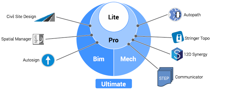
One of the key benefits of BricsCAD is that it has a wealth of Add-on modules to extend its capabilities and plugins to connect it with other applications. Furthermore, many of these 3rd party applications have been ported from AutoCAD® to run with the same features and functionality on BricsCAD. We are a partner for the following Add-ons:
Communicator for BricsCAD
Extends the Import/Export capabilities to add support for the common Mechanical CAD(MCAD) file formats, such asSTEP, SolidWorks, Inventor, and Catia.


Frequently Asked Questions
More CAD Software

.jpeg)
Ready to Transform Your CAD Workflow?
Contact us today to discover how CAD Concept's first-rate support and expert training can elevate your design process.